|
|
|
|

|
EIAST Releases First Images of DubaiSat-2
Published Dec 8, 2013
|
The Emirates Institution for Advanced Science and Technology (EIAST) has announced that the recently launched DubaiSat-2 earth observation satellite has successfully been deployed in orbit and all systems have been tested and verified.
The first communication with DubaiSat-2 was established just over an hour after separation from the Dnepr rocket and the mission critical telescope was operated successfully and it captured the first image just 24 hours after launch, the area captured was of Seer Bani Yas island in Abu Dhabi.
DubaiSat-2 provides 1m resolution in the panchromatic band and 4m multispectral as well as a color 1m product, the imaging swath is 12 km and DubaiSat-2 has the ability to image and download more than 18,000 square kilometers a day from its Dubai Ground station baseed in Al Khawaneej.
Salem Al Marri, Assistant Director General for Scientific and Technical Affairs, EIAST, said: “The launch of DubaiSat-2 marks a milestone for EIAST, our team has participated in the design and development of 50% of this mission and it has taken over 5 years of development, it is a very proud moment for us to see the results of all the hard work and dedication of the team, The satellite is the culmination of joint efforts over the last five years between the UAE and the South Korean development team and throughout the long mission development time in Korea our team has done its best to lift the UAE flag high into space and make sure we continue developing the UAE and its young engineers.
“Since its launch, DubaiSat-2 has orbited the globe capturing images from all five continents, the satellite has imaged over 833 images, which is equivalent to 120,000 square kilometre. These images will be utilized in many such as in monitoring development projects, urban planning, environmental monitoring, and in different value added products developed by EIAST team to support decision makers in different sectors. We plan to work with all government departments to ensure maximum usage of these images for the benefit of UAE and its people.,” added Omran Sharaf, EIAST’s Director of Space Image Processing & Analysis Department, EIAST
Commenting on the operation of the satellite, Mohammed Alharmi, Director of Ground Services Department, said: “The satellite operations team at EIAST was successful in stabilizing the satellite and testing all subsystems. The first contact with the satellite was established 90 minutes after launch, and the team used two different ground stations to track the satellite and monitor its condition. Once we made sure that the system was stable we started imaging different areas around the globe to test the camera and calibrate the sensors”
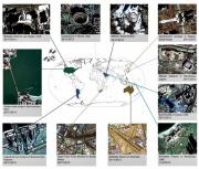
EIAST has released images from DubaiSat-2 taken from all over the world in 1 meter resolution, the areas imaged include the Golden Gate bridge in San Francisco, Tokyo Bay, The Coliseum in Rome and an image of Burj Khalifa taken just before National Day on December 1st.
DubaiSat-2 weighs 300 kg and is 2 meters in height and 1 meter wide. It is equipped with an electrical propulsion system that allows the control of its altitude above ground level and modifies it automatically in the event of any deviation from the orbit through a set of predetermined and saved commands sent from the control station. The new satellite is equipped with innovative technology to enhance maneuvering capability and increase agility by 300 per cent as compared to Dubai Sat-1.
DubaiSat-2 was launched into space from the Yasny Launch Base in Russia on board the Dnepr space launch vehicle on November 21, 2013.
EIAST was established by the Dubai Government in 2006 with the goal of promoting a culture of advanced scientific research and technology innovation in Dubai and the UAE, and enhancing technology innovation and scientific skills among UAE Nationals. It is mainly involved in outer space research and development; satellite manufacturing and systems development; space imaging; and ground station services and support for other satellites.
Posted by
VMD - [Virtual Marketing Department]
|
|
|

